The line from Albany to Eucla.
- Home, index, site details
- Australia 1901-1988
- New South Wales
- Overview of NSW
- Telegraph lines
- Telegraph Offices
- Date stamps
- Forms
- Envelopes
- Rates
- Stamps
- Queensland
- Overview of Qld
- Telegraph lines
- Telegraph offices
- Date stamps
- Forms
- Envelopes
- Rates
- Stamps
- South Australia
- Overview of SA
- Telegraph lines
- Telegraph Offices
- Date stamps
- Forms
- Envelopes
- Rates
- Stamps
- Tasmania
- Overview of Tasmania
- General developments
- Reports
- Organisation
- Telegraph lines
- Telegraph Offices
- Date stamps
- Railway lines
- Forms
- Envelopes
- Rates
- Stamps
- Overview of Tasmania
- Victoria
- Overview of Vic.
- Telegraph lines
- Telegraph offices
- Date stamps
- Forms
- Envelopes
- Rates
- Stamps
- Ephemera
- Western Australia
- Overview of WA
- Telegraph lines
- Telegraph Offices
- Date stamps
- Forms
- Envelopes
- Rates
- Stamps
A major issue for Western Australia was that, since the Colony was formed as a part of NSW to stop any colonisation activities by the French, Western Australia was the first and last port at which ships carrying the mails would stop. The opening of the Overland Telegraph Line in 1872 then meant that not only would Western Australia lose the advantage of receiving news from England first, but it would receive no current news and would have to wait weeks if not months for any news because of the lack of telegraphic facilities.
The Western Australian line was constructed along the southern coast from Abany to Eucla. The main sections describing the creation and the construction of this telegraph line are:
- financing and planning the construction of the link;
- the Tenders;
- construction:
Stage 1: planting the first telegraph pole;
Stage 2: Albany to Esperance;
Stage 3: Esperance to Eucla.
- the new 1927 line;
Planning for the WA-SA link.
The Inquirer of 15 July 1874 reported a discussion in early July in the Legislative Council: "The Colonial Secretary, in moving that the sum of £15,000 stand part of the Estimates for 1875 towards the extension of the telegraph from Albany to Eucla, spoke at considerable length, and with much force, on the undoubted and immense advantages which the proposed line would confer upon the colony and proceeded to show, from facts and figures, that the work when completed would not only be an inestimable commercial boon but remunerative. He estimated that the present trade between this colony and Indian and Eastern ports would ensure at least one thousand messages annually to the Adelaide and Port Darwin line and that, at the lowest, 500-600 messages per month could be relied upon for intercolonial traffic. In addition to this there would also be the business supplied by ships calling here seeking freights and by the monthly passengers by the P. & O. Company's steamers calling at Albany.
The estimates of the cost of construction and of the business likely to be done had been submitted to Mr. Todd, the South Australian Superintendent of Telegraphs — than whom probably no man in the world was more capable of giving an authoritative opinion upon the subject — and Mr. Todd saw no reason to doubt their correctness and fully concurred that the time had arrived when the work should be undertaken.
One of the immediate results of the project being initiated would be the almost certainty of cable communication being extended to our shores by a company already formed and that too, without the expenditure of a single penny by this colony in the work, but merely on condition of a concession of land. Having further dwelt on the merits of the project, Mr. Barlee confidently appealed to the House to support the motion that £15,000 stand part of the Estimates for 1875 towards carrying out the work".
In the Budget speech on 10 July, the Colonial Secretary noted: "the whole expense could be defrayed out of the current revenue without borrowing a sixpence for the purpose and it was calculated that the work could be completed in eighteen months or, at all events, two years from the date of its commencement. A sum of £28,500 would cover the entire cost of constructing the line from Albany to Eucla, inclusive of the erection of stations on the route and all conceivable expense of every nature. As the work, if undertaken, would extend over a period of one year, it was only proposed to place £15,000 on the Estimates for 1875 for the purpose of carrying it on".
Little was known of the countryside through which the line was to pass - the same situation as for the Overland Telegraph Line. For example:
- in 1841, the important explorer Eyre had struggled through under conditions which made it impossible for him to make more than passing reference to the sterility of the strip of land immediately bordering the sea;
- John Forrest, on his coastal trip of 1870, made more extensive observations, but the route he followed, particularly over at least the 300 miles west of the border, was some distance inland, and consequently detailed information relating to landing facilities, cartage of material, nature of the country for the purpose of sinking wells for water, etc., could not be obtained.
Mr. Fleming, Superintendent of Telegraphs, originally recommended a direct survey of the line, with a view to set forth the real capabilities of the several landing places hereinafter mentioned; and he suggested the chartering of a vessel and the formation of a party for this purpose.
He advised the adoption of the coast line because materials may be landed at convenient distances, and because this line runs through immense patches of country set down by Mr. H. Y. L. Brown, the Government Geologist, as of silurian and metamorphic formations.
Mr. John Forrest, of the Survey Department, who has traversed the whole country, and had a perfect knowledge of it, expressed his concurrence as to the adoption of the coast line, but considered the chartering of a vessel to convey persons to examine the country would be a waste of time and money. He gave reliable opinions from his own observations, and other sources, of the various harbors along the coast. He does not hesitate to affirm that fresh water can be obtained in abundance at the several places indicated for telegraph stations.
Western Australian Times, 9 October 1874.
Consequently Superintendent Fleming drew up elaborate and detailed specifications for the work including details of "every coach screw and scientific instrument requisite for each of the sections" which would span the planned 800 mile line. Forrest agreed with Fleming's details.
| This map continues to the Goldfields. | ||
| This map continues to Albany and the southern region. | 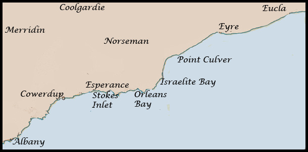 |
This map continues to Eucla and Port Augusta in SA. |
In summary, Fleming's specifications divided the line into 12 sections:
Section I. Albany to Longitude 118 deg. 43 min., Cape Riche Harbor, sixty (60) statute miles. At Cape Riche there is a good landing place. The track proposed to be followed generally is that known as "Wellstead's Road"; there will be clearing of standing timber nearly all over this section, and a maximum cartage over fair country of thirty miles.
Section II. From Cape Riche Harbor to Longitude 119 deg. 22 min., Mount Barren Station, sixty (60) miles. On this section there are two rivers to cross, the Gairdner and the Pallinup. There is a good landing place in the Western corner of Bremmer Bay. There will be a few miles of thickets to clear, and a maximum cartage of thirty miles.
Section III. From Mount Barren Station to Longitude 110 deg. 45 min., Cowerdup, Phillips River, under " Peak", forty-four miles. The line here will cross the "Fitzgerald", pass under Middle Mount Barren, and cross the Hamersley River, and pass over a good deal of rough country. The landing place is Mary Ann Cove; the maximum cartage twenty-two miles. The country is very open; very little fresh water in summer.
Section IV. From Cowerdup to Longitude 120 deg. 36 min., Darkanattup, thirty-eight (38) miles. The line here will follow generally Mr. Forrest's track. There is a landing place close to Darkanattup, at Starvation Boat Harbour. The maximum cartage nineteen miles and no difficulties.
Section V. From Darkanattup to Longitude 121 deg. 9 min., Stokes' Inlet, Shoal Cape, thirty-eight (38) miles, following the same track. There is a good landing place in Fanny's Cove. The Rivers Young, Margaret and Oldfield are no obstacles. The maximum cartage nineteen miles.
Section VI: From Stokes' Inlet to longitude 121 deg. 48 min., Esperance Station, forty six (46) miles. This section is covered with sand-hills, and may require close poling. By keeping along Mr. Forrest's track, the country is clear and the salt lagoons may be avoided, and there are no other obstacles. There is a good landing place at the west end of Esperance Bay. The maximum cartage twenty-three miles.
Section VII: From Esperance Station to (Duke of) Orleans Bay, forty-six (46 miles.) This section is chiefly open sand plain and scrub. The line will travel about three miles inland. The landing place is at the bay, and the maximum cartage fifteen miles. The Duke of Orleans Bay is a splendid harbor; there are also landing places at Lucky Bay, Thistle Cove, &c, &c, in this section.
In 1880, a Dutch brig went aground seven miles east of Orleans Bay. The Captain of the brig thought they were hundred miles from civilisation - so the crew and passengers waited. In June 1882, a telegraph line repairer was riding past and saw the masts of the ship. He went down to the beach to ride across the sand - to the wondrous joy and amazement of the lost souls. A boat was summoned (by the linesman) and it took them to Esperance.
Section VIII: From Duke of Orleans Bay to Longitude 123 deg. 30 min., the Bellinger Islands, fifty-six (56) miles. This section passes over rather rough country, and the maximum cartage is estimated at thirty-three (33) miles, there being a landing place near the island.
Section IX: From Bellinger Islands to Longitude 123 deg. 46 min., Israelite Bay, thirty (30) miles. In this section the thickets may be avoided by keeping a mile or two inland along a salt marsh. There is a good landing at the Bay, and a maximum cartage of fifteen miles.
Section X. From Israelite Bay to Longitude 124 deg. 40 min., Weld Station, a watering place west of Culver Cliffs, seventy (70) miles. The country near the coast for the first twenty miles is covered with a low scrub, after which there are twenty-five miles of drift sand-hills. By keeping inland along salt marshes these might be avoided. There is an abundance of water in the drift sand-hills. In fine weather the timber could be landed all along this section. The maximum cartage may be taken at twenty miles.
Section XI. From Weld Station to Longitude 126 deg. 28 min., Eyre Station; a watering place at the west end of Hampton Range, one hundred and forty-six (146) miles. This is considered the most difficult and costly section. The section is necessarily a long one, and the country is rough, abounding in thickets and limestone and granite. A landing place can be found at the west point of the range, and the maximum cartage about eighty miles. No permanent water exists along this section and no doubt difficulty will be experienced in carting.
Section X11. From Eyre Station to Longitude 128 deg. 55 min., Eucla Station, one hundred and sixty (160) miles. In regard to this section, Mr. Fleming proposes, if practicable, to run the line between Forrest's track and the coast, because he believes there are several places on the low sandy shore where materials may be landed in favorable weather, and he knows of nothing to be gained by following the track, which runs about fifty miles inland. Water is shown in rock holes, but no doubt water will also be found in gorges and gulleys on lower lands near the coast. The maximum cartage over the section is estimated at fifty miles. It is very clear and grassy under the range, which is never more than about twelve miles from the sea, and gets closer till at Eucla it is only one mile, there are also many rock water holes along the cliffs. The line would be much more substantial, also, than if constructed along the sand-hills near the sea shore.
The entire distance is 794 miles but deviations may increase this length at the rate of one in sixty.
There had also been considerations about a submarine cable down the coast of Western Australia as being an alternative to an overland line reaching the northern shores. Such a line could then be extended overland from King George's Sound to the east.
The Western Australian Government was going to complete all construction activities from Albany to Eucla itself. Hence tendering was not an issue.
James Fleming simply called to his Office two good men in whom he had complete faith. They were Charles Price and Jonathan Parrish. He appointed Price as the person solely responsible for the line and Parish as his Overseer. He subsequently wrote each a memorandum which approximately set out their responsibilities.
During the construction, Fleming kept in touch with Price and Parish in various ways. Although their appointments were far from being in accordance with today's practices, both men completed their tasks in the best ways that anyone could have (and quicker than could be done by todays standards). They certainly fulfilled all the faith Fleming had placed in them.
On 1 January 1875, H. E. Governor Weld - as the last public act of his official life in Western Australia - placed in position the first post of the telegraphic line to connect Albany, and therefore the rest of the colony, with Adelaide and, through her, with the outer world.
The construction work proceeded very smoothly. In contrast to the South Australians, who had great experience through the construction of the Overland Telegraph Line, the Western Australians had little experience - their lines having only just reached Geraldton in the North and Albany in the South over a period of about five years.
The West Australian construction teams used jarrah for their telegraph poles while the South Australians opted for tubular metal telegraph poles.
Sections 1 to VI (to Esperance):
The first Telegraph Office to be opened was at Bremer Bay on 9 March 1876. The South Australian Register reported later in the month as follows:
"We learn that the (Western Australian) Superintendent of Telegraphs has just returned from visiting this work in progress on the Eucla telegraph line and that the first station - at Bremer Bay - is erected and the work has commenced on the Esperance Bay station. Upon the arrival of the telegraph wire and insulators next month, the erection will be commenced forthwith and, with the aid of a field operator, the work will constantly be en rapport with head quarters. We look forward with great interest to the time when the wires of the neighboring colonies are joined to ours at Eucla".
In another Report written about this time, James Fleming noted:
I have been to within 140 miles of Eucla and selected station sites. Poling has been commenced on Culver Cliffs, in the fourth section and the general progress is very satisfactory. One party is now close to Esperance Bay, having been detained six weeks in consequence of loss of forage and supplies in a cutter from Albany during a gale".
Western Australian Times, 31 March 1876:
The newspaper reported that "the following report (to the end of February 1876) of the progress of the Eucla Telegraph Line has been very courteously placed at our disposal by the Government. It is from Mr. Price, the Surveyor in Charge, and will be read with interest":
Esperance Bay Station,
February 26th, 1876
(Ed. just over a year from the start and section 6 is nearly complete).
The works may be said to have reached Esperance Station for, although they are not as yet erected quite up to the Station site, poles have been laid along the line ready for fixing in their respective positions, which will be accomplished within 3 days.
This marks the actual distance (on the ground, not in number of poles) poled over since my last report at about 150 miles.
The general direction and nature of the country so far as the Young River was treated in the above mentioned report (sic). This river is crossed about one mile north of its junction with Stokes' Inlet, at a favorable spot, the landing place at Fanny's Cove being about 4 miles southward. To have approached which nearer would either have been necessary to have crossed Stoke's Inlet, where it is from 1 mile to 1½ miles in width, or to have hugged the sea coast, and gone over very rough, sandy coast hills, both in approaching and departing from the above landing.
After leaving the Young, it follows generally the direction specified, until nearing Maninnup. The required course would have involved winding in and out and crossing the numerous salt lakes and swamps in that locality. Instead, the line now passes close along the North shore of Lake Gage, thereby making a better and straighter line and avoiding altogether the swampy country.
Immediately on passing the eastern extremity of the lake, it turns to the S.E., and very soon follows the old course. There is no obstacle the whole distance, with the exception of the Gage River which is trifling. There is not a doubt about what is the most suitable line that could have been found: the straightest, abundance of fresh water along it and good sinking ground, and lengthening the carting little if any. In fact, in my opinion, it is advantageous to the contractor.
The approach to Esperance is over bad country, sand hills and hummocks (which were unavoidable without keeping many miles inland) and the carting being very bad. The departure will not be so bad owing to the kindness of the Messrs. Dempster's overseer, who himself shewed me the best pass out through them. Without a local knowledge, this might have not been noticed. It would be useless erecting the line close to the beach round the bay as shown on the tracing forwarded with Mr. Fleming's memo, the sand being of too loose a nature. It will be nowhere, for 10 miles after leaving the station, farther than 1 mile inland at the end of which it is close again, and there is a good landing called here "Rossiter Harbor" which will be of great assistance.
The erection of the station on the site gazetted will be commenced at once and will be pushed on with all vigor so as to be in readiness to receive the furniture which I am informed by Mr. Fleming's memo will be shipped per next trip of the vessel.
The work will now proceed rapidly for some distance, the carting being nominal, there being another good landing 10 miles on in this Bay.
From what I can gather, from good authorities, we shall have to keep rather more inland than contemplated after leaving the Bay 10 miles on as, round near the coast, rough country and bad carting will be met with. Further, all agree as to the impossibility of carting material away from Duke of Orleans Bay - a magnificent harbor but everything landed there will have to be hand carried for at least ¾ of a mile. If such be the case - and there is no reason for doubting the truth of the information, coming as it does from men thoroughly acquainted with it - it will be useless landing any poles there.
I am at once going on over that country as far as the Thomas and shall know better where landing places would be of service and if any but, as I mentioned, there is every reason to believe the information from those who have given it. Indeed no more serviceable knowledge of the country could be obtained from any other source unless much time is spent in traversing the country to and fro.
C. D. PRICE,
Surveyor in Charge of Eucla Telegraph line.P.S. March 1st. The "Mary Ann" having been delayed, I reopen this to mention that the work is finished to the station.
On 22 November 1876 various newspapers carried the report that "At the beginning of August 1876, there were five hundred miles of the Albany-Eucla line poled and three stations erected, leaving about two hundred and thirty miles and two stations (including Eucla) to erect.
The first two stations, Bremer Bay and Esperance Bay, have been opened to communication with Perth and the third station - Israelite Bay - will likewise be opened soon. The wires and insulators being already distributed over that section and the party at work erecting".
A subsequent report in the Press noted:
"Esperance Bay Telegraph Office was the second office on 7 September 1876. The Israelite Bay station on the Eucla Telegraph line — some 60 miles from Esperance Bay — was opened on Tuesday morning 5 December 1876. Wiring the next (Eyre) station has commenced and everything in connection with the work is reported to be progressing satisfactorily".
At this time, Fleming was anticipating that communication between Perth and Eucla would be realised by the middle of 1877. The most significant setback had been the stranding of a vessel along the coast carrying poles and materials.
A report in the Sydney Morning Herald of 24 July 1877 gives some insight into the nature and pace of the construction activity:
"The Western Australian portion of the work will be about 960 miles long. It was begun about three months before ours was commenced and it is expected that it will be finished by the end of September next. From Bremer Bay to Culver, the line is within a very short distance of the coast. From that point to Eyre's Sand Patch it is a little distance inland and thence to Eucla it will be close to the water. On the 10th of June the wire had reached the Sand Patch but, in order to save time, only half the proposed number of poles has been erected in some parts. The supports are of wood and are 18 feet high".
Supplies were dropped off at the Eucla Jetty. Then the Post and Telegraph crews began the job of scaling the nearby sand-hills before following the route taken by explorer Edward John Eyre along the tops of the Bunda Cliffs and across the Nullarbor Plain. Jarrah poles were used throughout.
Some ships had difficulty with conditions when trying to unload supplies, For example, on 7 August 1877, the schooner Fanny Wright, which was carrying telegraph poles to Eucla, was salvaging cargo from the Freebridge in Waterloo Bay when she was holed by an anchor. Although she was quickly run ashore, she was found to be too badly damaged to repair.
At least three other transport vessels - the Twilight, the Catabunup and the Mary Ann - were also totally wrecked during the progress of the work. The Mary Ann was wrecked on her return voyage [to Fremantle] on the night of the Friday 13 July 1876, on Bellenger Islands. No lives or any of the cargo was lost. Mr. Fleming regarded the accident as unfortunate but one which would not interfere with the progress of the work. Miles was the navigator of the Mary Ann, and he was also the contractor for delivering materials to the telegraph line. He had always believed that one should not sail on a Friday.
There were few accidents and only one death. At Point Culver, one poor fellow, named Michael Reddin, lost his life on the 7th of January, 1877 when attempting, with others, to land poles in a heavy surf. The boat he was in capsized and he was pinned underneath and drowned before he could be released. But, fortunately, notwithstanding that, this was the only life lost.
At the end of construction, Price noted that "the anticipated trouble with natives was happily not realised; those I met with were of peaceful disposition, and rendered valuable assistance in locating water, carrying dispatches, and in many other ways. The difficulties encountered were in other directions, lack of landing places, or suitable harborage for the transport boats, the heavy nature of the country through which material had to be carted, miles of flinty limestone tableland where drilling had to be resorted to, and always the scarcity of potable water".
At Eucla a neat station of eight rooms was erected for the use of both the Western Australian and the South Australian operators.
The Western Australian section of the line was completed in December 1877. Communication was effected between Adelaide and Perth at 4 pm on 8th December 1877, a distance of 1,986 miles.
Telegraph rates from Western Australia to Europe were nearly £1 per word. Bishop Salvado, from the New Norcia Benedictine mission, paid £40 for a telegram of 51 words to the Pope in the Vatican two days after the line to Adelaide opened (Ed. don't know what he said!!).
On 6 November 1896, the Coolgardie Miner reported that "The telegraph line between Coolgardie and Eucla has been interrupted since 6 o'clock on Wednesday evening. The interruption has taken place on the Eucla side of the Norseman. A repairer was to leave the Norseman early yesterday to repair the breakage and it is expected that the line would be in good working order shortly. The interruption necessitates all the business that usually comes via Eucla being repeated from Perth".
In October 1894, the duplex system was introduced on the Perth Eucla line. Although there were many difficulties at first, the transmission system finally conferred substantial benefits on the telegraphic operations.